
Meta Dropped the DMA. Advertising Still Has No Map of Its Own.
On June 22 Meta stopped honoring Nielsen's DMA codes in automotive model ads. Nothing about the ground changed. Every model keyed to those codes still has to be rebuilt.
Nate Woodman · August 6, 2026
On June 22, Meta stopped honoring Nielsen's DMA codes in automotive model ads. Campaigns still using them stopped delivering until advertisers rebuilt them against Comscore Markets. From April 20 Meta had been warning advertisers whose vehicle feeds still carried DMA codes. New York stopped being 501 and became "2001".1
Nothing about American geography changed. Both maps carve the country into about 210 television markets. What changed is who owns the numbering, and advertising had been renting it.
A licensed map is a subscription, not a standard.
That rent lands on the part of advertising that is already automated. The AI deciding where budget goes is not a language model. It is the mix model that splits credit across channels, the bidder that prices an impression in milliseconds, and the estimator that reads a geo test. Every one of them takes geography as an input, and none of them can tell when that input changes meaning. Google's Meridian, its open marketing mix model, takes geographies as user-supplied partitions and warns in its own documentation that different geo aggregation grouping methods can lead to different results.2 A boundary that moves mid-flight breaks the comparison the test was built on, the answer changes with it, and nothing in the output says so.
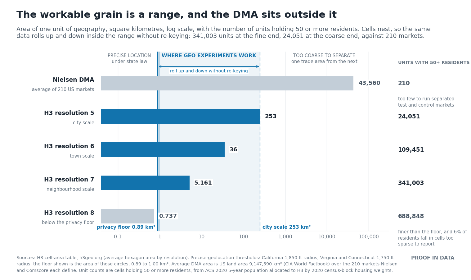
Three things have to be true of a unit the industry can build on. It has to be open, so nobody licenses it and nobody can renumber it. It has to be fixed, so boundaries do not shift during an active test the way postal and administrative geography does. And it has to be correctly grained, which means bounded on both sides. The ceiling is the trade area: one DMA averages 43,560 square kilometres and the country divides into 210 of them, too few to hold test and control markets that do not bleed into each other. The floor is where the law stops you: state privacy statutes treat location as precise inside a circle of roughly 1,750 to 1,850 feet, about nine tenths of a square kilometre, and a unit that small holds too few people to report on anyway.3 A geo test has to live between those two lines.
A unit that satisfies all three already exists and nobody owns it. H3 is a hexagonal grid that covers the earth in nested resolutions, where every point falls in exactly one cell at every zoom level. Resolutions 5 through 7 fall between the two lines.4 Because the cells nest, the range is the point rather than any single rung on it: the same data rolls up and down inside it without being re-keyed, fine where the signal is read, coarser where the buy executes and the lift is measured. At resolution 6, about the size of a town, the United States divides into 109,451 cells holding fifty or more residents, against the 210 the DMA map gives you.5 Resolution 8 falls below the floor. Administrative boundaries convert into weighted sets of cells, so postal-keyed sales files and customer records still join. Platforms keep their own encodings and convert in and out.
A model wants the opposite of what a licensed market map provides. It wants many units rather than few, because 210 partitions cap how much can be estimated at once. It wants units that nest, so the same history pools coarse and reads fine without being rebuilt. And it wants identifiers that hold still, because a feature that renumbers has to be remapped before any history built on it can be reused. The same goes for the newer representations: place embeddings, numeric fingerprints of a location that models consume directly, are only as stable as the unit they are computed on.
This is the standards work I have been doing alongside others in the industry who want the same thing: a geography advertising holds in common rather than leases. The full proposal, with the crosswalks and the privacy math, is the 168 Grid, from my work with Ether Data. If you are the one who has to re-key a panel, Ether published the conversion: rebuilding a geo test after the DMA.
Meta's switch is not the problem. It is the demonstration. The next platform that changes vendors will renumber the map again, and every model and every measurement keyed to the old numbering will quietly stop meaning what it meant.
Sources
- Meta for Developers, "Transitioning to Comscore Markets for automotive model ads," March 13, 2026: Meta replaced Nielsen DMA targeting in automotive model ads with Comscore Markets. Vehicle feeds could carry Comscore Market IDs from March 23; Meta began issuing feed-ingestion warnings for remaining dma_codes on April 20; campaigns still using Nielsen DMA stopped delivering on June 22, 2026. The field changed from a single numeric DMA code (501) to an array of string IDs (["2001"]). Meta's stated reason: a partner solution "more sustainable and scalable for long-term performance and measurement." Nielsen and Comscore each define about 210 US markets.
- Google Meridian documentation, geo-level modeling: "Different geo aggregation grouping methods can lead to different MMM results."
- State privacy statutes define precise geolocation by the radius of a circle: California 1,850 feet; Virginia and Connecticut 1,750 feet.
- H3 published average cell areas: resolution 5 is 252.9 km², resolution 6 is 36.1 km², resolution 7 is 5.161 km², resolution 8 is 0.737 km². A circle of radius 1,750 to 1,850 feet covers 0.894 to 0.999 km², which falls between resolutions 7 and 8.
- Unit counts are H3 cells holding fifty or more residents, the threshold below which a cell is too sparse to report: 24,051 at resolution 5, 109,451 at resolution 6, 341,003 at resolution 7. Computed from ACS 2020 5-year population allocated to H3 by 2020 census-block housing weights. At resolution 8, which sits below the privacy floor, six percent of residents fall in cells under the threshold.